|
|
|
|
|
|
|
Günter Nitschke
|
|
Publication in:
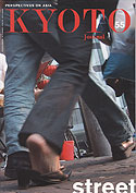
KYOTO Journal 55: Street - Perspectives on Asia, September 2003 |
|
|
|
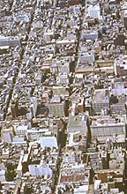
Not only foreigners in Japan but Japanese themselves struggle daily to find specific addresses of homes, public buildings or businesses even in their own towns. Street names and house numbers do not exist in Japan, even not in Tokyo, the world’s largest conurbation. * 1.
In any other city or metropolis, be it New York, Paris or Moscow, it doesn’t require special training to find any place given that one knows the exact address and has a map to navigate from. Orientation is somehow standardized in the world outside Japan.
But give a name card with an address you wish to reach to a taxidriver in Tokyo or Fukuoka and you will be surprised that even someone who has obviously passed an examination on the spatial intricacies of his city like a taxidriver, will not find it easy to locate the said address. When he has entered the vicinity of the target area he will phone the place directly to get further instructions, or stop and ask an old lady in an odd corner store or look at a map posted somewhere with the exact names of all residents of that area. None gets upset by the delays and the guesswork, everyone is polite about it and will finally arrive at his destination.
It would be an insult to claim that the Japanese – even after World Wart II when all major Japanese cities were bombed flat – did not have the intelligence to introduce street names and house numbers to make orientation easier if they had wanted to. I personally do not know of a single example of a street with a normal Western-style name proper and numbers for plots at each side. .There must be a profound, perhaps unconscious, reason why the Japanese chose to live with a system of urban spatial orientation which is nearly not understandable to an outsider, and why they continue to do so.
Structure and orientation of cities outside Japan and some parts of Korea and Taiwan are based on a particular paradigm of urban space familiar to all of us: all space is subdivided by linear coordinates, the corridors, streets, the roads, avenues, and boulevards named after cultural heroes or just numbered like in Manhattan, and individual plots are placed in numerical order with even and odd numbers at either side along these coordinates. Any plot is therefore clearly defined in space. The system of streets and roads occasionally forms a rectangular urban grid, but in actual fact can take any other freer form of network.
Literally from cradle (go to a large maternity ward in a hospital) to grave (no doubt the grave of our beloved ones has a particular number in a particular row) we are completely immersed in this spatial paradigm. It governs all space making and space perception in the cities and minds of people of people in most civilization.
|
|
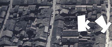
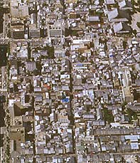
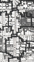
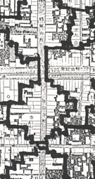
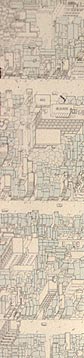
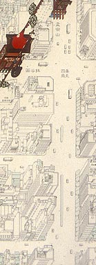
| Kyoto CHO in the Middle Age |
 |
|
|
|
| THE JAPANESE URBAN SPATIAL PARADIGM |
|
The indigenous Japanese paradigm of space which determined urban structures and human orientation within them is not more complex or less rational than the common “Western” one. It is just different. There are two aspects to it.
|
| First, it is not based on a network of linear coordinates, but on a system of spatial nesting, that is, a hierarchy of urban areas nested within each other. Thus, an address proper in Japan, somehow in the fashion of Russian dolls, starts with the name for the largest areal container, the prefecture or ken, to or fu, followed by the next smaller areal nest, the name of the city or shi, again followed by the name of a smaller sized urban ward or ku, ending with the name of the neighbourhood, the cho or machi with an apocryphous house number attached to it. This number has no intelligible link to a particular location along an anyway nameless street it is situated in. It is an official number of land registration. Your plot might have the number 243, your immediate neighbour that of 502-12. The relation between these two numbers could be compared to the relation between your car registration number and that of your neighbour. This above method makes it practically impossible to find a particular premise purely by the given names of consecutively nested areas, for foreigners and Japanese alike. More recently high-rise buildings have been given flowery names of their own, such as
American
Heights
or Mont Blanc Chalet, naturally completely unrecognizably garbled up by Katagana. |
|
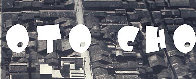
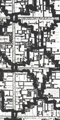
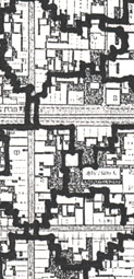
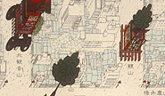
| right: Kyoto CHO at present |
|
|
|
|
Second, since individual households, the ie, which are the smallest spatial and social cells in Japanese cities, do not have individual house numbers, the identity of an individual household in Japan disappears within the smallest social group, the neighbourhood or cho. The fact of being born into a particular cho or having moved into to it makes one automatically a member of the o-chonai or chonaikai, the neighbourhood association, the smallest collective self-governing unit in the Japanese brand of democracy, going back in origin to the middle ages.
The physical structure of Japanese cities and its expression in Japanese language has its roots in the social behavior of its people, traditional and modern. Social life in Japan is and has always been for, by and of the group. Also all education in Japan has been and still is based on the promotion of group-, not individual consciousness. And the smallest group in Japan – beyond a family’s household - is the cho in Japan. In one’s life in Japan one may belong to different groups simultaneously, but one hardly ever appears or is valued as an individual.
The same can be said of the Japanese paradigm of urban space. It is ambiguous. Individual house-holds belong to a number of areal units, but physically and experientially they do not appear as individual units with their own identifiable name and number.
|
|
|
KYOTO CHO: HISTORY
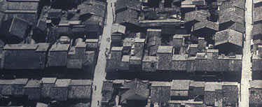
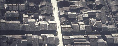
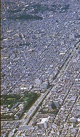
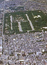
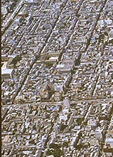
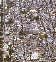
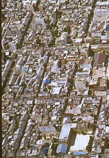
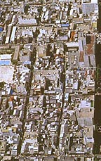
At first sight there seems to be one great exception to this pervading paradigm in the history of Japanese urban space, and that is Kyoto, Japan’s Capital up to 1868. Since its foundation it has combined the linear and nested system of space allocation and identification. In Kyoto all streets were given and still have names proper or just numbers. The street network was laid out after Chinese models in rectangular grid fashion. Such a grid of clearly named streets combined with sequential house-numbers would have been absolutely sufficient to locate any urban plot beyond any doubt like it has been done in the rest of the world. But that would have been not in line with the Japanese psyche and social reality. So what happened in Kyoto is unique in human urban history and urban space: the names of the north-south or east-west streets do appear by name on your postal address (even though there are no physical signposts of them in Kyoto) but only to pinpoint the crossing from which you are then sent east or west, south or north to an area, the described cho or neighbourhood, which might have from 40 to over a hundred households. They have no further signs of identification besides the ominous “car” registration number mentioned before. Naturally, if one mistakes the name of the cho or neighbourhood area for the name of a street, - as foreigner invariably do -, then one faces the odd situation that one and the same street in a Japanese seems to change its name mysteriously every 120 meters, that being the original length of one cho. In this context here I omitted any reference to the huge number of rental tenement houses on the roji, the narrow cul-de-sacs within each cho.
Here, in very abridged form, what happened to the street in Kyoto in history and what potential it might hold form the future.
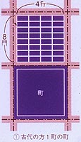
In the original layout of Heiankyo, the Kyoto of today, the chi or basic city block, was 120 meter square, was surrounded by a high wall and was subdivided for the common folk by E-W and N-S lanes into 32 individual lots clearly numbered for control and tax purpose (A). At this stage the inhabitants of the capital were simply encaged subjects in a highly regulated liturgical community with the emperor at its head, not citizens. Everything had its fixed and controlled place, time and order.
|
|
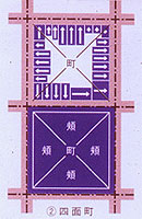
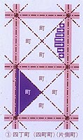
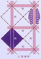
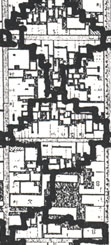
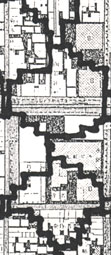
| the Kyoto CHO and its metamorphoses |
|
|
boundary of the cho |
| placement and direction of individual townhouse |
 |
|
A-the initial Kyoto cho |
|
|
|
|
| right: medieval neighbourhood pattern superimposed on Heian era rectangular street grid |
|
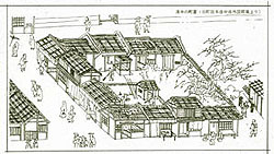
| The first metamorphosis of the original cho as a walled infill-block took place around 1200. With the Shoguns ruling Japan from far-away Kamakura, the described order of an Imperial State slowly faltered and weakened enough, so that some inhabitants of a cho in Kyoto could punch holes into the walls surrounding their wards and offer their produce for sale to passers-by without being punished. This marks the start of free enterprise and the birth of free citizens. After the collapse of the wall the cho slowly got divided diagonally into four triangular parts the houses of which now faced the street directly. The center of the cho was held in common ownership (B). This is the stage when the cho shows four different faces to the outside. It is also the stage of the birth of the kyo-machiya, the traditional Kyoto urban townhouse.
In the next metamorphosis in the early Middle Ages the originally square cho splits up into four triangular cho with their own names*2 (C).
The third metamorphosis was generated by the previous condition from the Muromachi Era on. The two cho facing each other over the street formed a completely new cho, - in name and shape -, taking the street - which was really not a thoroughfare anyway but a public open place to meet and communicate – into its center (D). This new cho could be completely closed by gates at both ends of the street for defense purposes or simply for the night.
|
|
|
|
|
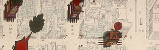
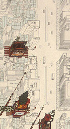
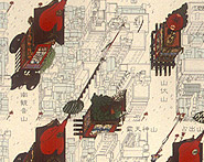
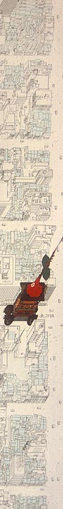
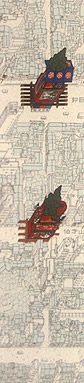
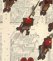
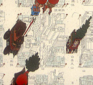
right: placement of the festival floats at the Kyoto Gion Matsuri.
graphic design by Nishiwaki Tomokazu. |
|
|
Thus, today’s unique double grid of Kyoto city was born: the grid of the City Hardware in the form of the rectangular urban street-grid from Heian times, and superimposed on it the grid of the City Software in the form of the neighbourhood system of the cho born in the Middle Ages. They both run at 45 degrees angle to each other. Thus, visually a map of the central old part of the city looks very much like a tortoise pattern. The Gion Matsuri held each year in July, its internal organization, naming of main floats and processional routing, is completely structured on this unique pattern.
|
|
|
 |
|
 |
|
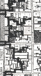
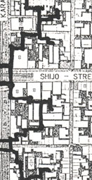
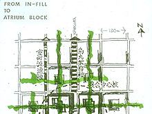
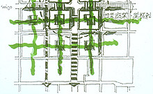
| the potential CHO in modern times |
|
|
KYOTO CHO: RENEWAL
A fourth metamorphosis of the cho is presented here from 1990 proposals by the Institute for East Asian Architecture and Urbanism for the renewal of central Kyoto around the main crossing of Shijo and Karasuma Dori, an area constituting somehow the heart of financial district of Kyoto.
The four cho at that intersection have a living population of zero by now. Keeping them alive is meaningless. A few large companies and banks have bought up the land leaving a few unusable left-over spaces free at the center of each cho. With a completely erratic land-subdivision and 31 to 45 meter high buildings on it, the cho has definitely reached its worst condition in history.
Our proposal suggested a more economic and user friendly renewal of that area in the form of Atrium Blocks used by various companies in consultation and agreement with each other. These blocks were completely turned inwards towards a central light atrium which was to reach down to basement level. At this level this new urban grid for pedestrians only would directly connect with the subway system, and stretch from the center of one original cho to the surrounding ones, from one green atrium to the next. Other pedestrian corridors could be achieved by bridges in mid-air connecting neighbouring atrium blocks. Such renewal of inner urban city blocks is not at all a novelty in urban design but has been realized over the last ten years in various big cities, such as Hong Kong and cities of the USA. It turns city life quasi inwards, away from the noxious gases and noise of urban traffic. It gives the city back to its citizens.
|
|
|
*1. See G. Nitschke, From Ambiguity to Transparency – Unperspective, Perspective, and Aperspective Paradigm of Space, in Louisiana Revy, Vol.35, No.3, June 1995, for a more elaborate essay on the same subject.
*2. Adapted from Historical Atlas Kyoto, Chuo Koronsha, Tokyo, 1994.
|
|